Please find included the Impact Based Warning for the Western Cape and Namaqua Region of Northern Cape.
Hazard
Alert Level
Affected Municipalities
Valid From (SAST)
Valid To (SAST)
Damaging Waves
Yellow(L2)
(High likelihood of Minor Impacts)
M_Bergrivier, M_Bitou, M_Cape Agulhas, M_Cape Agulhas, M_Cederberg, M_City of Cape town, M_George, M_Hessequa, M_Kamiesberg, M_Knysna, M_Matzikama, M_Mossel Bay, M_Nama Khoi, M_Overstrand, M_Richtersveld, M_Saldanha Bay, M_Swartland, M_Table Bay
21/01/22 06h00
22/01/22 11h00
Discussion: Wave heights of 4-6m with wave periods of at least 18s and strong south-easterly winds with wind speed of 40-60km/h are expected between Saldanha Bay and Cape Agulhas on Friday morning (21/01/2022), spreading to Alexander Bay by the afternoon and to Plettenberg Bay in the evening. These conditions together with spring tide will result in higher wave heights.
Impact: Difficulty in navigation for small vessels and personal water craft which may lead to vessels being at risk of taking on water and capsizing. Localised disruptions of small harbours or ports is possible for short period. Localised damage to coastal infrastructure is possible. Localised disruption to beachfront activities. Public at risk of being swept of coastal rocks due to infrequent large waves.
Instruction: Small vessels are advised to seek shelter in harbours, bays or inlets.
Report any weather related incidents to the Garden Route Disaster Management Centre at: 044 805 5071.
Legal notice:
“This warning from SA Weather Service must be communicated as received and may not be altered under any circumstance.
It must be forwarded or communicated in its entirety and no portion hereof may be replicated or copied and distributed.”
Please find included the Weather Advisory for the Western Cape and Namaquland Region.
Alert Level
Affected Municipalities
Valid From (SAST)
Valid To (SAST)
Advisory
Beaufort West, Bergrivier, Breede Valley, Cederberg, City of Cape Town, Drakenstein, Hantam, Kamiesberg, Kannaland, Karoo Hoogland, Laingsburg, Langeberg, Matzikama, Nama Khoi, Oudtshoorn, Prince Albert, Stellenbosch, Swartland, Theewaterskloof, Witzenberg
21/01/22 06h00
23/01/22 00h00
Discussion: Very hot to extremely hot conditions will result from predominantly light northerly wind flow over the interior of the Western and the Northern Cape Provinces.Temperatures are expected to reach up to 39 degrees Celsius on Thursday and at least 40 degrees Celsius on Friday and Saturday over the interior of the West Coast, Cape Winelands, southern high ground of Namakwa District (N.Cape), Central and Little Karoo. These persistent high temperatures might result in heat wave conditions in some places.
Impact: In an extreme hot environment, the most serious health and safety concern is heat stroke. Heat stroke can be fatal if medical attention is not available immediately.
Instruction: Avoid prolonged direct exposure to the sun as far as possible and drink plenty of water. Limit strenuous outdoor activities, find shade and stay hydrated. Never leave kids in the car unattended. Make sure your animals have access to enough water.
Report any weather related incidents to the Garden Route Disaster Management Centre at: 044 805 5071.
Legal notice:
“This warning from SA Weather Service must be communicated as received and may not be altered under any circumstance.
It must be forwarded or communicated in its entirety and no portion hereof may be replicated or copied and distributed.”
The Garden Route’s nearly 300km long beaches stretch from the whitest sandy beaches of Witsand, past the sky-blue waters of Plettenberg Bay, ending at Natures Valley. Known for offering a safe destination, the Garden Route is a preferred destination for families, adventure-seekers and beach-goers, to name a few.
Coastal municipalities boast twenty blue flag beaches offering locals and tourists quality water and clean public facilities. Numerous coves and lagoons, as well as untouched indigenous forests, can be seen along the N2 from east to west.
Amagene Koeberg, Garden Route District Municipality’s Tourism Coordinator, says that offshore there is the possibility to see Southern Right Whales, dolphins, and great white sharks.
“Come and explore the Garden Route, you will surely become a returning visitor of our area,” said Koeberg.
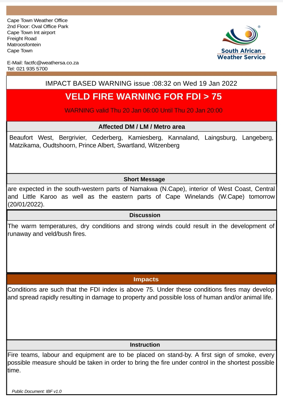
The Cape Town Weather Office has issued an extended (24 hour) Impact Based Warning for the Western Cape and Namaqua Region of the Northern Cape as follows:
Discussion: The warm temperatures, dry conditions and strong winds could result in the development of runaway and veld/bush fires.
Impact: Conditions are such that the FDI index is above 75. Under these conditions fires may develop and spread rapidly resulting in damage to property and possible loss of human and/or animal life.
Instruction: Fire teams, labour and equipment are to be placed on stand-by. A first sign of smoke, every possible measure should be taken in order to bring the fire under control in the shortest possible time.
Report any weather related incidents to the Garden Route Disaster Management Centre at: 044 805 5071.
________________________________________
Legal notice:
“This warning from SA Weather Service must be communicated as received and may not be altered under any circumstance.
It must be forwarded or communicated in its entirety and no portion hereof may be replicated or copied and distributed.”
Impact Based Weather Warnings for Western Cape and Namaqua: Veld Fire Conditions
17 January 2022
Hazard
Affected Municipalities
Valid from (SAST)
Valid to (SAST)
Veld Fire Conditions
Beaufort West, Kannaland, Karoo Hoogland, Laingsburg, Oudtshoorn, Prince Albert and Swellendam
18/01/22 10h00
18/01/22 18h00
Discussion: The warm temperatures, dry conditions and strong winds could result in the development of runaway and veld/bush fires.
Impact: Conditions are such that the FDI index is above 75.Under these conditions, fires may develop and spread rapidly resulting in damage to property and possible loss of human and/or animal life.
Instruction: Fireteams, labour and equipment are to be placed on stand-by. At first sign of smoke, every possible measure should be taken in order to bring the fire under control in the shortest possible time.
SOUTH AFRICAN WEATHER SERVICE
Cape Town Weather Office
2nd Floor: Oval Office Park
Cape Town Int airport
Freight Road
Matroosfontein
Cape Town
E-Mail: factfc@weathersa.co.za
Tel: 021 935 5700
Report any weather-related incidents to the Garden Route Disaster Management Centre at: 044 805 5071.
Impact Based Weather Warnings for Western Cape and Namaqua: Yellow level 2: Damaging Waves
17 January 2022
Hazard
Alert Level
Affected Municipalities
Valid From (SAST)
Valid To(SAST)
Damaging Waves
Yellow(L2)
(High likelihood of Minor Impacts)
Bergrivier, Bitou, Cape Agulhas, Cape Agulhas, Cederberg, City of Cape town, George, Hessequa, Kamiesberg, Knysna, Matzikama, Mossel Bay, Nama Khoi, Overstrand, Richtersveld, Saldanha Bay, Swartland and Table Bay
18/01/22 15h00
20/01/22 00h00
Discussion: Strong to gale force SW’ly winds (50-70km/h) are expected from Tuesday afternoon between Cape Point and Plettenberg Bay. This will cause rough, choppy seas with quick successive steep waves. From Wednesday, winds drop down, but wave heights increase to 4-6m along the entire coastline (Alexander Bay to Plettenberg Bay) from the morning. Wave heights may reach 7m along the southwest coast on Wednesday. Periods of 16s is expected on Wednesday and Thursday which will result in high energy waves. Springtide this week will also result in waves reaching further up the beach.
Impact: Difficulty in navigation for small vessels and personal watercraft may lead to vessels being at risk of taking on water and capsizing. Localised disruptions of small harbours or ports is possible for short period. Localised damage to coastal infrastructure is possible (mainly Wed-Thurs). Localised disruption to beachfront activities. The public at risk of being swept off coastal rocks due to infrequent large waves (Wed-Thurs).
Instruction: Small vessels are advised to seek shelter in harbours, bays or inlets.
SOUTH AFRICAN WEATHER SERVICE
Cape Town Weather Office
2nd Floor: Oval Office Park
Cape Town Int airport
Freight Road
Matroosfontein
Cape Town
Legal notice: “This warning from SA Weather Service must be communicated as received and may not be altered under any circumstance. It must be forwarded or communicated in its entirety and no portion hereof may be replicated or copied and distributed.”
Joint Media Release: SALGA Western Cape hands over a cheque of R54 862 to Kwamdlezane Baby Care Centre as part of its Mandela Day initiative for 2021
For Immediate Release 17 January 2022
The South African Local Government Association (SALGA) Western Cape in collaboration with the Executive Mayor of Garden Route District Municipality (GRDM), Alderman Memory Booysen identified Kwamdlezane Baby Care Centre in Plettenberg Bay as part of SALGA’s initiative for Mandela Day 2021. A cheque of an amount of R54 862 has been handed over to the centre, on Monday, 17 January 2022 by SALGA and the Executive Mayor.
During his keynote address, Ald. Booysen said that their municipality tends to focus on primary and high schools when they do outreaches, however, after discussions with my Mayoral Committee, they have decided to shift the focus towards Early Childhood Development centres (ECDs).
Ald. Memory Booysen during his keynote address explained how he nervously awaited SALGA’s feedback about if they were planning to support the beneficiary from Plettenberg Bay.
Khalil Mullagie, SALGA Provincial Executive Officer conveyed a message of support to Kwamdlezane baby Care Centre.
Khalil Mullagie, SALGA Provincial Executive Officer, Sipeshihle Mafani (Principal, Kwamdlezane Baby Care Centre), Richard Bosman (Acting Municipal Manager, Bitou Municipality) and Ald. Memory Booysen (GRDM Executive Mayor).
Mayoral Committee members from GRDM with Sipeshihle Mafani (second from right).
Kwamdlezane Baby Care Centre own is a centre headed by a 25-year-old Sipeshihle Mafani, who took over the centre from her mother when she passed away in 2017. Mafani thanked SALGA and the Executive Mayor for the funds donated to the centre. She said it will be used for the better upkeep of the children accommodated at the centre.
“Thank you for your continued support. This donation will definitely go a long way in sustaining our mission and it will definitely make a difference in the centre,” she said.
GRDM Mayoral committee member for financial services, Cllr Anco Barker said the municipality needs to bend a tree while it’s young. This means that the GRDM should make an impact on the lives of ECDs.
“We tend to forget that we need to start making a difference to the lives of community members when they are still young,” said Barker.
She also thanked Kwamdlezane Baby Care Center committing to report on how they will share the funds donated to them.
2021 marked 12 years of Nelson Mandela Day Celebrations under the theme “Take ActionInspire Change – Make Every Day a Mandela Day”, Action Against Poverty” while Mandela Day calls to action remain a general call to reach out to those in need, SALGA’s focus was to be on the challenge of food security, sanitation and ECD work.
Since the pandemic, this devastating reality worsened. Staff members at SALGA were called to support efforts related to these goals during Mandela Month 2021.
SALGA Western Cape’s Provincial Director of Operations Mr Khalil Mullagie mentioned that they meant to do the donation in July last as part of SALGA’s Mandela Day initiative. But due to the Covid-19 lockdown, the project was delayed.
“Covid-19 disrupted our plans last year, as a result, this project was delayed. But we are happy that we got to finally handover the much-needed funds to Ms. Mafani’s centre,” said Mr Mullagie.
He further said that, with the help of the GRDM, they identified this centre as the suitable beneficiary, because the Principal of the ECD is a young person contributing to her community by creating jobs through the centre.
End
Issued by: South African Local Government Association Western Cape
For further media enquiries, please contact: Joyce Moholola
082 874 9222
jmoholola@salga.org.za
Herman Pieters
081 4555 699
communications@gardenroute.gov.za
Chief Communication Officer
Garden Route District Municipality
Beaufort West, Hantam, Kannaland, Karoo Hoogland, Khâi-Ma, Laingsburg, Oudtshoorn, Prince Albert
15/01/22 11h00
15/01/22 22h00
Discussion: Showers and thundershowers are expected to develop over the interior of the Namakwa as well as the Central and Little Karoo from early afternoon, where some may become severe with quick and heavy downpours (30-40mm/hour) which can lead to flash flooding as well as possible large amounts of small hail (diameter of 2cm and less).
Impact: Localised flash flooding of susceptible roads, low-lying areas and bridges (main concern being the N1 and the Swartberg Pass) which can lead to difficult driving conditions especially where the roads are slippery due to the combination of hail and pooling of water on the roads and the heavy downpour that can reduce visibility. This may contribute to minor vehicle accidents and longer travel times. Localised damage to infrastructure and settlements (mainly informal) and localised and short term disruption to municipal and other essential services are also possible.
Instruction: If possible stay indoors away from metal objects. Do not seek shelter under trees or tall objects. Do not go fishing or play golf as both the golf clubs and fishing rods are good conductors of electricity. Be aware that any combination of hail, strong winds and/or heavy downpours can accompany the storms.
Legal notice: “This warning from SA Weather Service must be communicated as received and may not be altered under any circumstance. It must be forwarded or communicated in its entirety and no portion hereof may be replicated or copied and distributed.”
SOUTH AFRICAN WEATHER SERVICE
Cape Town Weather Office
2nd Floor: Oval Office Park
Cape Town Int airport
Freight Road
Matroosfontein
Cape Town


 SOUTH AFRICAN WEATHER SERVICE
 SOUTH AFRICAN WEATHER SERVICE


 Legal notice: