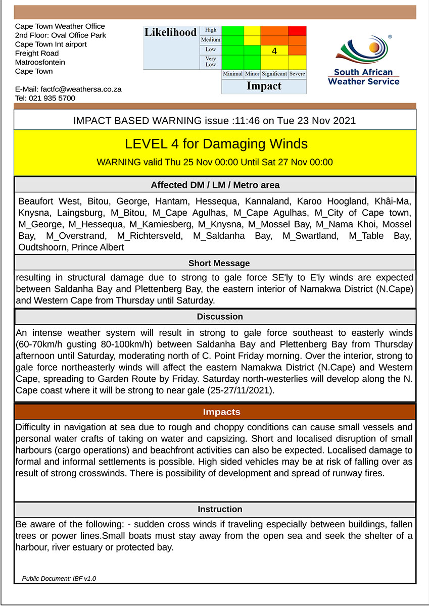
Garden Route District Municipality Once Again Celebrating World Wetlands Day on 02 February
For immediate release
2 February 2022
Today, 2 of February 2022, the Garden Route District Municipality (GRDM) is once again celebrating the World Wetlands Day. World Wetlands Day is celebrated annually and aims to raise awareness globally about the vital role of wetlands for humans and the entire world’s eco-system.
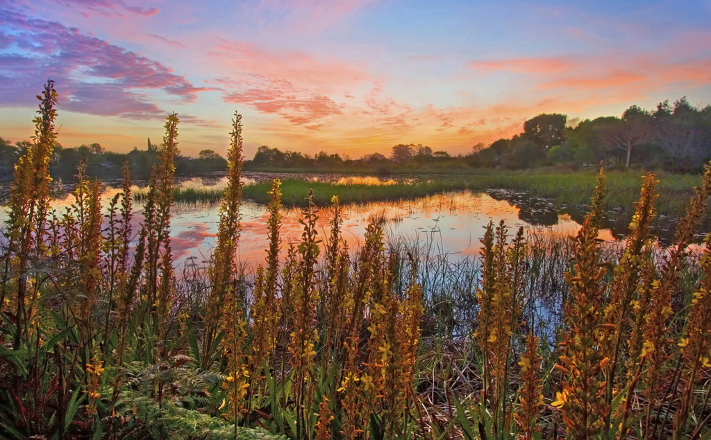
A significant number of wetlands can be found throughout the Garden Route, including one protected under the Ramsar Convention. The internationally known Wilderness Lakes Ramsar Site falls within the Garden Route National Park, covering an area of 1 300 hectares and includes estuarine lakes of Rondevlei, Langvlei and Eilandvlei, the Serpentine channel, and a dune system. A Ramsar site is a wetland site designated to be of international importance under the Ramsar Convention; an intergovernmental environmental treaty established in 1971 by the United Nations Educational, Scientific and Cultural Organization (UNESCO). The treaty provides for national action and international cooperation to conserve wetlands and to use their resources in a sustainable manner.
The wetlands within the Garden Route are considered to be high-value ecological infrastructure. They provide vital habitat for flora and fauna, which forms part of a larger critical ecosystem to the environment. These include flood attenuation, water filtration, erosion control and water storage (regulatory services), as well as food provision, supply of raw materials and clean drinking water (provisioning services). The wetlands within the municipal boundaries also play a pivotal role in disaster risk management, as well as reducing the impacts of climate change.
Dr Nina Viljoen, Head of Environmental Management at GRDM said: “Within the Garden Route however, a significant number of the wetlands are under threat, or have already been lost. This is largely due to historical degradation, deliberate draining of wetlands to make way for development and agriculture, inappropriate development within the close proximity to the wetlands, poorly regulated agricultural practices, contamination through chemical, sewage, effluent and stormwater seeps, sedimentation, water abstraction and the spread of invasive alien plants”. In light of this, Dr Viljoen added that there is an urgent need to increase awareness of wetland importance and to incorporate natural wetland resource considerations into municipal governance mechanisms and planning. She emphasised: “Careful management, and investing in the maintenance of healthy wetlands, as well as the rehabilitation and restoration of damaged or degraded wetlands, are needed. This will ensure the continued provision of these vital ecosystem services to the municipality”.
GRDM Wetlands Strategy (2017-2022)
The GRDM developed a Wetlands Strategy (2017-2022) in collaboration with, and support from, the Local Action for Biodiversity: Wetlands South Africa (LAB: Wetlands SA) programme, and the International Council for Local Environmental Initiatives, Africa Secretariat (ICLEI AS). Through the development of this Strategy, gaps in the support of wetland management within the district were identified, and improved wetland management strategies were therefore incorporated within the Strategy.
The GRDM Disaster Risk Assessment (2020-2021)
The GRDM recognises that wetlands are of immense value, especially when it comes to disaster risk reduction. According to a GRDM Disaster Risk Assessment (2020-2021), wetlands have the ability to contribute towards disaster risk reduction by means of its flood attenuation, water filtration and related water security functions. These functions are also extremely important in climate change adaptation, and needs to be conserved in order to assist in the mitigation of future climate change risks. The GRDM therefore seeks to enhance the conservation and management of the districts’ natural wetland resources. This is done by integrating biodiversity issues into its local government support, planning and decision-making processes.
As part of its disaster risk assessment, the GRDM identified a high flood risk in the coastal and lagoon areas of the district, particularly during the winter months. This impact is worsened by increasingly degraded wetlands.
According to the GRDM Climate Change Report (2018), most wetlands are classified as either ‘moderately modified’ (between 25% and 75% of the wetland land cover is natural) or ‘heavily to critically modified’ (less than 25% of the wetland land cover is natural). Wetlands within the district therefore face a significant number of threats, all of which have the ability to either destroy the wetland entirely, or severely compromise function and provision of ecosystem services.
In order to conserve wetlands in the Garden Route, and to reduce the number of threats they are facing, Dr Viljoen said: “The GRDM, its local municipalities within its area of jurisdiction, as well as all the stakeholders, need to adapt to a ‘new normal’. The complex interactions between society and wetland ecosystems need to be approached in an integrated way, she added”.
It is essential to increase the monitoring and regulation of new environmental authorisation applications that will impact wetlands. Through this, sustainability projects will be identified that will benefit the neighboring communities to identify community upliftment opportunities and products/services for sustainable wetland use. This will allow the prioritisation of wetlands and the implementation of innovative and internationally-used approaches to help reach sustainability goals and objectives. It is essential that the municipalities within the Garden Route district compile the best available spatial information on wetlands for inclusion in their Spatial Development Frameworks (SDF’s), as well as to include wetland management within their Integrated Development Plans (IDP’s).
The following related GRDM documents can be accessed on its website:
ENDS


 Legal notice: