Media Release: Development of a strategic framework for an alien and invasive biomass economy
For Immediate Release
13 July 2021
Announcement and invitation to participate: Development of a strategic framework for an alien and invasive biomass economy in RSA
A new initiative to develop a strategic framework for an alien and invasive biomass economy was initiated in June. The purpose of the initiative is to identify and unlock the opportunities of an invasive and alien biomass economy in South Africa that targets problematic alien and invasive woody biomass through ecosystem rehabilitation.
The clearing of alien and invasive woody biomass provides opportunities for developing green value chains that will support the restoration of ecosystems for climate change adaptation and mitigation, catalyse private sector financing and provide energy alternatives, amongst other uses. The initiative will support the uptake of an economy around the biomass use with the aim to support the creation of jobs.
“Every day, thousands of South Africans set out to the countryside, town and city perimeters to harvest significant amounts of invasive alien plant biomass in order to transform it into something useful which can be marketed and sold on any scale and format, or to simply utilise as firewood at their households,” says Cobus Meiring of the Southern Cape Landowners Initiative (SCLI).
“But exactly how big is the industry dependent on invasive alien, as well as invasive but indigenous bush encroachment biomass in South Africa? How deep and valuable is the market for products derived from these plants and trees? How do we go about giving the alien and invasive biomass industry a voice and assist it in growing in order to be more sustainable and to make an even more meaningful contribution to the fast-emerging green, circular and climate-ready economy.”
“To get a better understanding of these questions, SCLI, with support from the Department of Forestry, Fisheries and the Environment (DFFE) and its partners, is embarking on a process aimed at developing a strategic framework for the purpose of advancing the biomass industry in South Africa. The ultimate aim is to come up with a strategic framework and action plan, and a roadmap to the establishment of a National Biomass Industry Platform in the country,” says Meiring.
SCLI invites all who work directly and indirectly with invasive alien plant/tree material to support the initiative and join the series of national dialogues on the biomass economy.
Stakeholders in the biomass economy value-chain include entities or individuals involved in related research, the biomass-to-energy industry, timber manufacturers for the building and woodwork industries, companies manufacturing wood chips and shavings for example, for the poultry industry, manufacturers of sawdust, and companies producing charcoal from wattle and other types of invasive infestations. Businesses in the biochar, industrial-scale composting, harvesting equipment and transport services sectors are all encouraged to join in and provide critical input within the next few months, seeing that the baseline study will be concluded in October 2021.
Other stakeholders include South Africa’s national, regional and local authorities, non-governmental organisations (NGOs), water boards, water catchment agencies, mining companies, agricultural bodies and the forestry industry.
“Groups and individuals are encouraged to list their interests and concerns, make suggestions and make their voices heard,” says Meiring.
As a result of Covid-19 restrictions, the standard public participation processes, including extensive face-to-face interaction and meetings countrywide used to develop a strategic framework such as the biomass industry is just not feasible and for this purpose, a series of virtual dialogues is planned for those interested. The virtual dialogues will take place between August and September.
The final topics/themes for virtual participation by interested and affected parties will be announced in due course and will be made available to all relevant stakeholders who are registered on the biomass economy strategic framework database.
To register as a stakeholder/participant, interested or affected party, please send an email with your full contact details to Louise Mare, email: louisamare@gmail.com or contact her by sending a WhatsApp message to 082 078 1629 during office hours.
For more information, please follow the link: https://www.scli.org.za/announcement-and-invitation-to-participate/
Photo/s:
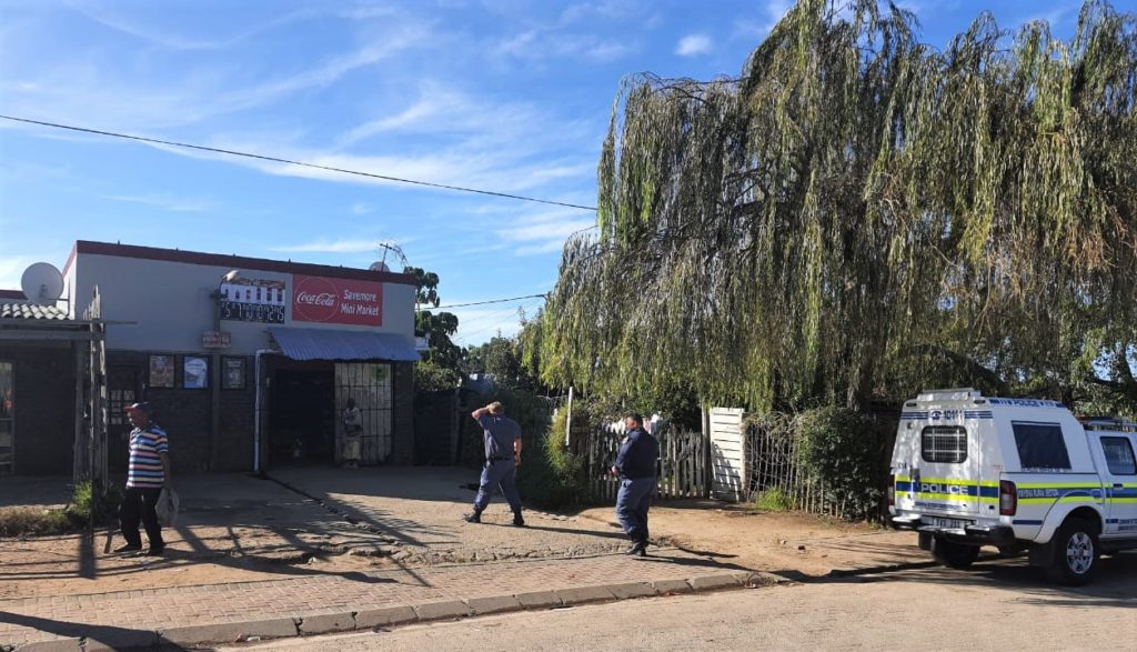
High-volume manufacturers, industrial-scale companies, and small-scale businesses in the invasive alien plant biomass value chain are invited to contact the biomass economy study group through SCLI to register on the database for further engagement. Stakeholders can include invasive alien plant contractors, entrepreneurs creating products by making use of invasive alien biomass as base material, and landowners making available biomass for biomass harvesting on their land, be that indigenous or to reduce bush encroachment. (Photo: SCLI)
MEDIA ENQUIRIES
Cobus Meiring, Chairperson, Southern Cape Landowners Initiative (SCLI)
Cell: 083 626 7619
Email: cobus@naturalbridge.co.za


 COVID cases

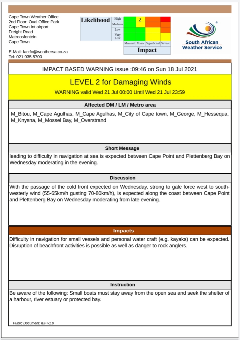
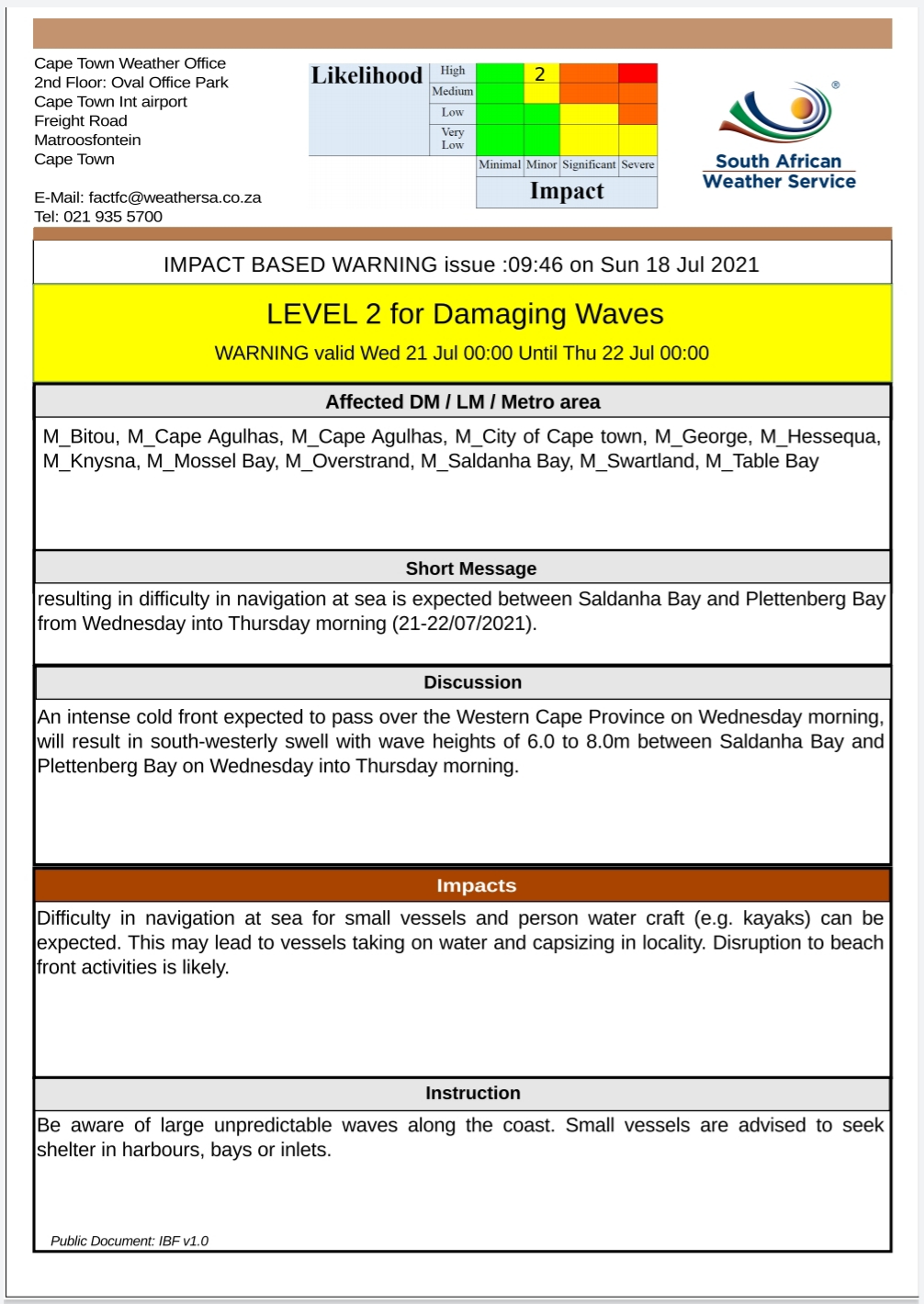
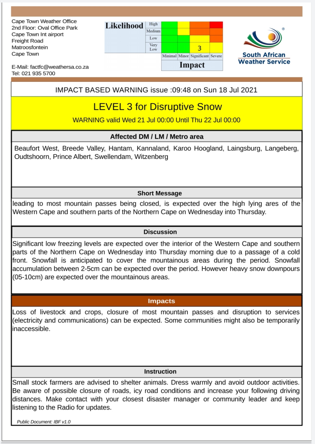
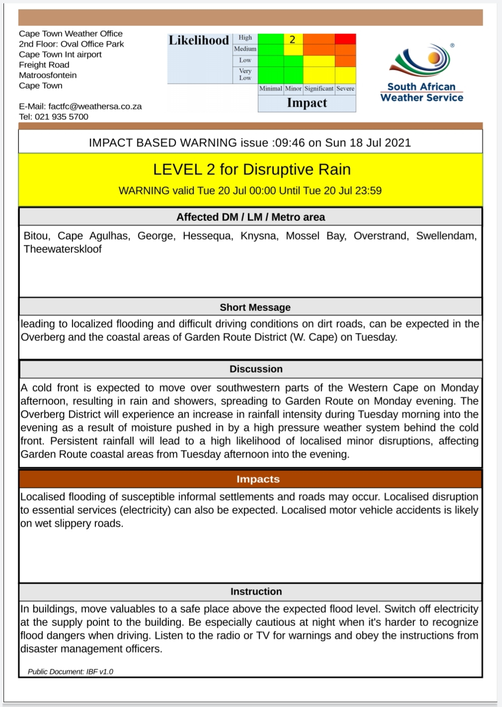


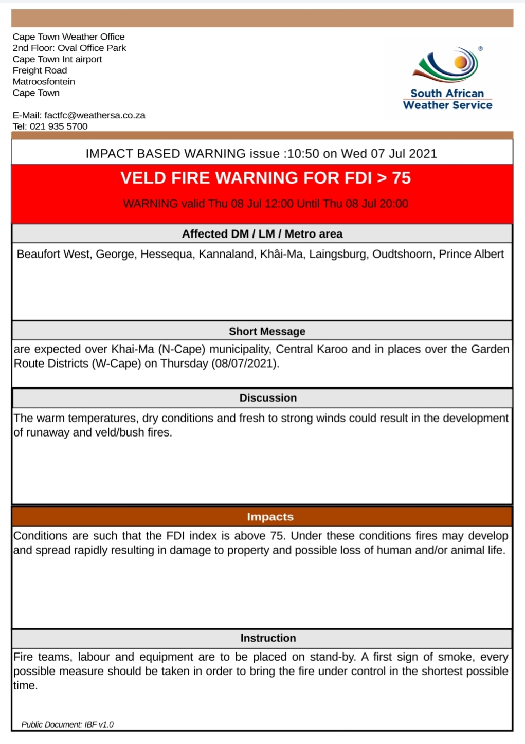

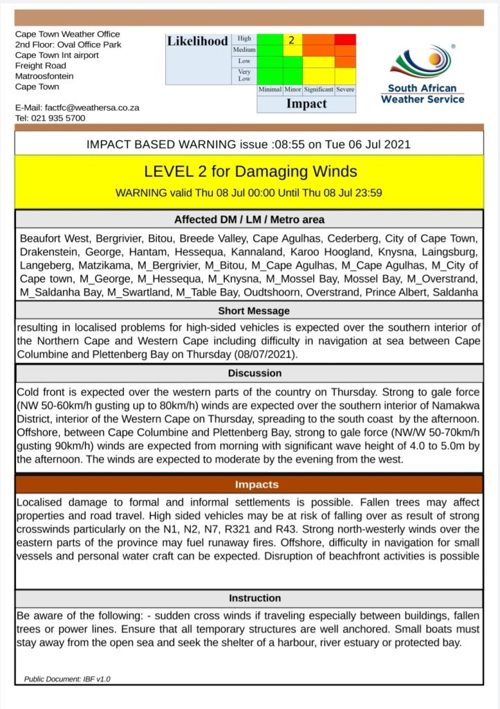 Report any weather related incidents to the Garden Route Disaster Management Centre at 044 805 5071.