
Author: Marillia Veldkornet

23 May 2022 Save the Date – Notice of Council Meeting – 27 May 2022 at 11:00

The Council meeting will be live streamed through the municipality’s official Youtube channel: www.youtube.com/channel/UC66RBZT0_U2_L4-zSn7yXJQ
19 May 2022 Media Release: Garden Route District Air Quality Awareness Campaigns have reached more than 60 000 people so far
Media Release: Garden Route District Air Quality Awareness Campaigns have reached more than 60 000 people so far
For Immediate Release
19 May 2022
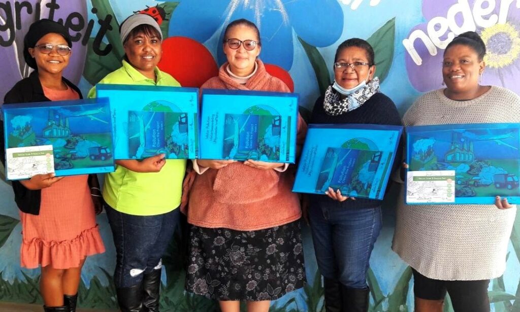
For the last seven (7) years, Garden Route District Municipality (GRDM) has incorporated air pollution education as part of its community outreach activities. The Air Quality awareness campaign was identified in response to the poor air quality status of informal settlements during winter seasons. Dr Johann Schoeman, District Air Quality Manager at GRDM, emphasised that the poor air quality status is amongst others sources, caused by fires used for cooking and heating purposes. In the pictures (below) are school representatives from various schools with their study packs.


With this in mind, a three-year formal tender was advertised for the procurement of services by a training provider to facilitate training at schools within the Garden Route. The tender was awarded to Mingcele (PTY) Ltd to develop study packs and facilitate the training at Primary Schools until 2024. Mingcele facilitates and manages several community development projects with a special focus on educational training support and environmental awareness.
Further to this, Dr Schoeman explained that the Western Cape Provincial Government Education Department was also approached to address the issue at primary school level. This effort resulted in the Clean Fires campaign now being incorporated as part of the Grade 3 curriculum. In order to reach as many learners as possible, and being inclusive in its approach, the course material is printed in isi-Xhosa, Afrikaans and English.
The course material covers the following air pollution aspects:
- What air pollution is;
- The health effects thereof;
- What causes air pollution;
- How you can help to reduce air pollution;
- How to make a fire;
- How to make a “cleaner” fire for heating purposes; and
- How to construct a stove from waste material.
Each participating school receives a study pack with study material -convenient for each teacher. The course material is in line with the Curriculum and Assessment Policy Statements (CAPS) and each resource pack consists of full colour posters, an educational game pack, lesson plans, worksheets in all three official languages of the Western Cape, a full colour booklet, a DVD including the lesson plans and worksheets with five plugins for an interactive whiteboard.
Dr Schoeman said: “Since its inception, the project reached most of the primary schools in the Garden Route district. The project is rotated in the region with this year again focusing on the Klein Karoo region. In total, 72 teachers and 2033 learners from 39 schools were reached, amongst others in Oudtshoorn, Uniondale, Volmoed, De Rust, Calitzdorp, Avontuur, Haarlem and Ladismith areas. GRDM’s officials were involved in the official hand-over of study packs to some of the participating schools.


When determining the current project impact on the receptor environment, Dr Schoeman highlighted: “It is anticipated that four (4) family members per child are reached with a cumulative impact of 8132 community members covered through the project for this year alone”.
The project statistics for the last four years are as follows:
2019: 37 schools and 72 teachers.
2020: 46 schools and 63 teachers.
2021: 66 schools and 151 teachers.
2022: 39 schools, 72 teachers and 2033 learners.
Seventy-two study packs were handed over to the participating schools. For the last 4 years, the project almost reached 60 000 people in the Garden Route.
In closing, Dr Schoeman said: “Continuous monitoring and evaluation of the project is taking place by means of follow-ups through social media (WhatsApp), email communication and completed attendance registers”. Adding to this he highlighted: “Due to the success of this project and the positive feedback received from the participating schools, the GRDM committed itself for another two years to expand its awareness outreach sessions”.
The GRDM Air Quality Unit encourages the public to contact their office at 044-693 0006 during office hours, for any further information regarding the project. To learn more about air quality, visit our page at: https://www.gardenroute.gov.za/air-quality/
Feature Image: Bersig Primary School
ENDS

11 May 2022 Notice: Standing Committee on Transport and Public Works: Public hearings on the Western Cape Provincial Transport Infrastructure Bill
![]() To:
To:
- All Mayors, Municipalities of the Province of the Western Cape
- All Speakers, Municipalities of the Province of the Western Cape
- All Municipal Managers, Municipalities of the Province of the Western Cape
STANDING COMMITTEE ON TRANSPORT AND PUBLIC WORKS: PUBLIC HEARINGS ON THE WESTERN CAPE PROVINCIAL TRANSPORT INFRASTRUCTURE BILL [B 5–2021]
The Standing Committee on Transport and Public Works will be facilitating public hearings on the Western Cape Provincial Transport Infrastructure Bill as indicated below.

The purpose of the Bill is to provide for the planning, declaration, design, construction, maintenance, control, management, regulation, upgrading and rehabilitation of roads, railway lines and related transport infrastructure in the Western Cape; and for matters connected therewith.
It would sincerely be appreciated if you would extend this invitation to all your Councillors in order for them to inform their ward committee members and the wider public accordingly. It would also be appreciated if you could forward this notification to any other person or institution that, in your opinion, may have an interest in the Bill. See attached advertisement.
Therefore, you are hereby cordially invited to submit written submissions as well as requests to make verbal presentations on such written submissions to the Standing Committee on Transport and Public Works for the attention of the Procedural Officer Mr Johan Coetzee at email: jcoetzee@wcpp.gov.za.
Interested persons and organisations who intend to submit an oral submission may do so by WhatsApp as a voice note (cell phone number 064 763 9034). Should you wish to appear before the Committee to make oral presentations you can direct your request to Mr Johan Coetzee (Tel: 021 487 1717, e-mail: jcoetzee@wcpp.gov.za or on the WhatsApp), which must include full contact details (name, email address and contact number), to the Procedural Officer.
Copies of the Western Cape Provincial Transport Infrastructure Bill will be available on request and an electronic version of the Bill is available on the Western Cape Provincial Parliament’s website (www.wcpp.gov.za).
Yours sincerely,
MR D AMERICA, MPP
CHAIRPERSON: STANDING COMMITTEE ON TRANSPORT AND PUBLIC WORKS
For more information, download the following documents:
Issued: Western Cape Provincial Parliament
ENDS

05 May 2022 Notice: Applications for Fencing Subsidies to assist Landowners are now open
05 May 2022 Notice: Applications for Fencing Subsidies to assist Landowners are now open!
Garden Route District Municipality gives subsidies for fencing on a yearly basis to assist landowners on neighbouring rural roads with fencing of their properties. This is subject to a budget as received from the Western Cape Government.
The funding will only be applicable on a subsidy basis. It effectively means that 60% subsidy will be contributed towards the cost of the fencing. The subsidy is determined by an average price for material. The material is deemed as 60% of total cost. Labour cost is deemed as 40% of the total cost and must be carried by the applicant. All initial costs must be carried by the applicant and subsidy will be paid out after the successful completion of the fence. For more information refer to the Fencing Subsidy Policy of Garden Route District Municipality.
The new fences must adhere to the specifications of the Provincial Government of the Western Cape: Roads Infrastructure Department. Minimum specifications will be made available to successful applicants.
Application process
- Application forms can be obtained from Mr Qamani Nkebana or Mr Lungisa Qendu at the Roads Transport & Planning Department. Contact numbers at the office are 044 803 1506 / 044 803 1577 or email Qamani@gardenroute.gov.za / Lungisa@gardenroute.gov.za.
- Alternatively download it from www.gardenroute.gov.za.
- Application period: 06 May 2022 to 03 June 2022.
- Applications will be audited and evaluated according to risk analysis by a panel.
Risk factors include: Status of road, traffic count, operating speed of vehicles, type of farming, condition of current fence, etc
- The panel outcome will be decided by 01 July 2022. All applicants will be informed. A fencing subsidy contract will be signed with successful applicants. Unsuccessful applicants can apply again in the next financial year.
- All fences must be fully completed by 30th November 2022 for payment before 28 February 2023.
- Payment will be done after an inspection and an approval for the fence has been made.
Click below to download all the applicable documents:
- Fencing Subsidy Notice / Advertisement
- Letter to Applicants
- Guidelines for the fencing of roads by adjacent Landowners
- Application Form and Annexures
- MBD4 Declaration of Interest
Closing date: 03 June 2022
Notice number: 36
MG Stratu
Municipal Manager
54 York Street
P.O. Box 12
George
6530