Skip to content Skip to left sidebar Skip to footer

Severe Weather Alert

27 July 2023 Media Release: A strong cold front and cut-off low expected to affect the Cape provinces this weekend, 28-30 July 2023

Media Release: A strong cold front and cut-off low expected to affect the Cape provinces
this weekend, 28-30 July 2023

For immediate release
27 July 2023

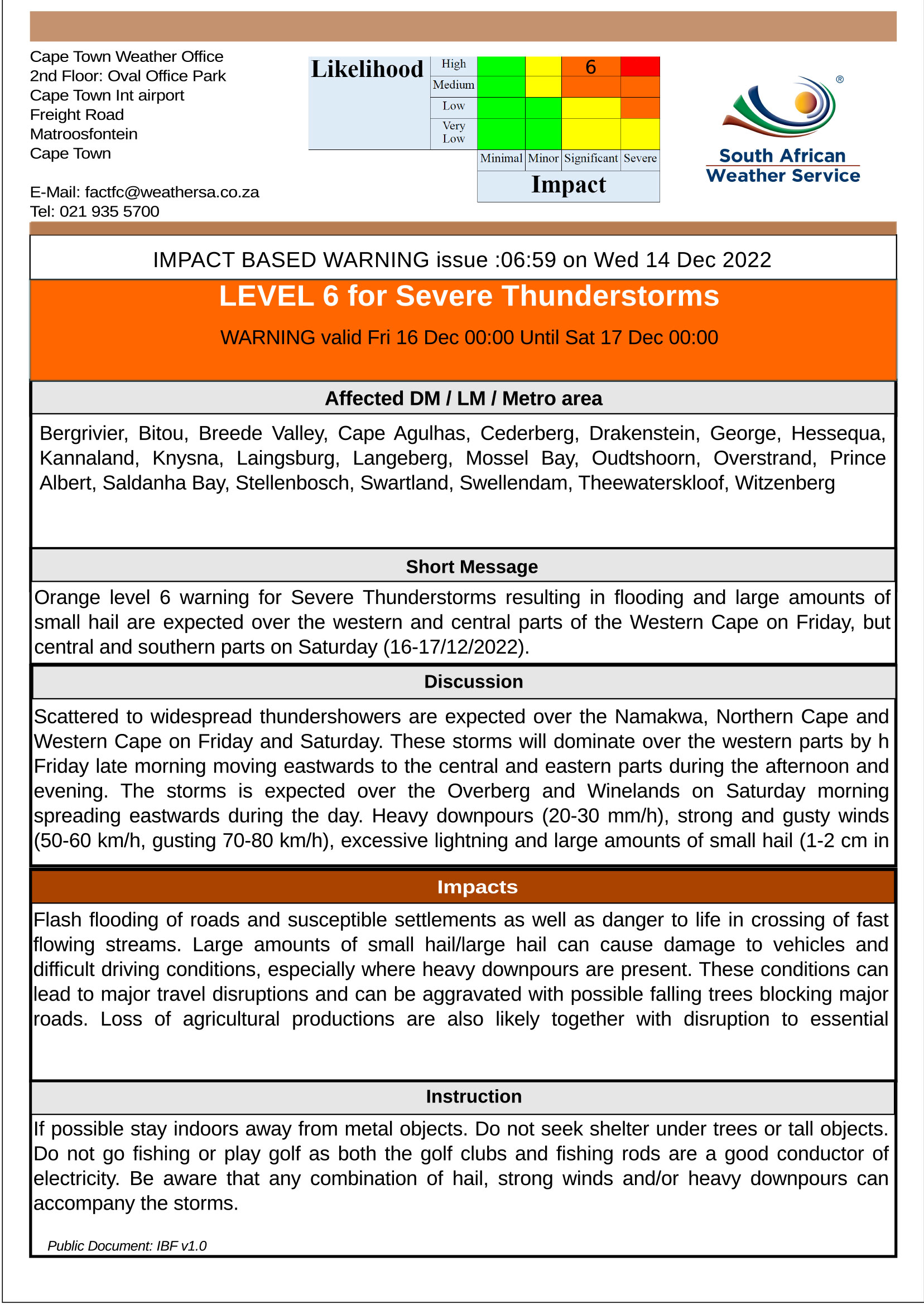
Heavy rainfall, very cold conditions, rough seas, snow, and strong to gale force winds are expected over parts of the Cape provinces this weekend as a strong cold front makes landfall on Friday evening, 28 July, along the west coast of the country. On Saturday, 29 July, a cut-off low rapidly develops over the Western Cape further exacerbating weather conditions. Although the Cape provinces will experience the brunt of these conditions, the central and eastern parts of the country will also experience cold to very cold conditions from Saturday evening into Sunday.

A strong cold front is expected to make landfall along the west coast of South Africa and Namibia during Friday evening, causing scattered to widespread showers and rain along the coast of the Northern Cape and the western parts of the Western Cape. Very rough sea conditions along the coastal areas and windy conditions over the central and western interior of the country are also anticipated.

On Saturday, a cut-off low (an extension of a deep low-pressure from the main westerly wave) develops over the Western Cape and is expected to spread to the south-western parts of the Eastern Cape during Saturday afternoon. Cut-off low pressure systems are well known for causing flooding, gale force winds and snowfall in winter. Widespread rainfall can be expected over the western and southern parts of the Northern Cape, most parts of the Western Cape, and parts of the Eastern Cape on Saturday. Heavy rainfall leading to flooding is possible over parts of the Cape Metropole, Cape Winelands, and especially the Overberg and Garden Route Districts of the Western Cape mainly on Saturday but already over the Cape Metropole from Friday evening. These conditions are expected to spread along the south coast of the Eastern Cape on Saturday afternoon.

Very rough seas (associated with strong winds), with wave heights between 4.0 and 6.0 m can be expected along the west coast from Friday night, spreading along the south coast of the Western Cape on Saturday, to the coast of the Eastern Cape on Saturday night and reaching the KwaZulu-Natal coast on Sunday. These conditions may cause disruption to beachfront activities and difficulty in navigation at sea for small to medium vessels. High seas with wave heights between 6.0 to 7.0 m can also be expected along the south coast of the Western Cape from Saturday afternoon into Sunday, spreading to the Eastern Cape coast on Sunday (see figure 2a), which can lead to possible beach erosion and put small to medium vessels at risk of taking on water or capsizing.

Snowfall is expected across interior mountain ranges of the Western Cape, the western and southern high ground of the Northern Cape and the high ground of the Eastern Cape from Saturday (see figure 2b) into Sunday and may extend into the Drakensberg region of KwaZulu-Natal and the extreme southern parts of the Free State on Sunday. Disruptive snowfall can be expected over the interior high ground of the Western Cape, the northern and central high ground of the Eastern Cape and the southern high ground of the Northern Cape on Saturday into Sunday, which may lead to loss of livestock, closure of mountain passes and result in some communities to be temporarily inaccessible.

Very cold conditions (maximum temperatures between 5°C and 10°C) are expected over the interior of the Cape provinces from Saturday into Sunday (see figure 3a and 3b), while cold conditions are expected to spread to the central and eastern parts of the country mainly on Sunday (see figure 3b).

The weather systems are expected to weaken significantly on Sunday while exiting over the south-eastern parts of the country, causing weather conditions to improve mainly from Sunday evening into Monday.

However, heavy ocean swell will continue to impact the southern and south-eastern coastline on Monday due to another cold front slipping along the southern coastal areas.

The South African Weather Service is closely monitoring this weather system and will update the public when needed. It is strongly advised that the public regularly follow weather forecasts on television, radio as well as social media platforms. Updated information in this regard will regularly be available at www.weathersa.co.za as well as via the SA Weather Service Twitter account @SAWeatherService.

Compiled by Wayne Venter
Edited by Elizabeth Viljoen
Approved by Tshepho Ngobeni

For technical and weather enquiries:
National Forecasting Centre: Tel: 012 367 6041

Media enquiries: Ms Hannelee Doubell: Manager, Communications;
Tel: (012) 367 6104; Cell: 072 222 6305; E-mail: hannelee.doubell@weathersa.co.za

ENDS

13 June 2023 Media Release: Very cold wet and windy weather to persist over the Cape provinces in the week ahead.

Media Release: Very cold wet and windy weather to persist over the Cape provinces in the week ahead.

For immediate release
13 June 2023

Very cold wet and windy weather to persist over the Cape provinces in the week ahead.

A well-developed, fast-moving cold front arrives over the Western Cape tomorrow, introducing very cold, rainy weather to all three of the Cape provinces. In addition, strong, gusty westerly winds over the interior of Western and Western Cape are expected to accompany the passage of the cold front. Given the dramatic drop in temperature, combined with persistent wet and windy conditions in the days ahead, small stock farmers are strongly encouraged to take mitigative action at an early stage to prevent stock losses due to exposure.

Moreover, the arrival of the cold frontal system tomorrow will be the first in a succession of such systems, expected to pass through the Cape provinces in the week ahead, on an almost daily basis.

Cold, windy conditions with occasional showers will therefore be a persistent feature of the weather over the southern half of the country, continuing until well after the long weekend.

The latest output from Numeric Weather Prediction (NWP) models, in particular the Unified Model (UM) (refer Figure 1 below) suggest that heavy rainfall may occur over parts of Western Cape tomorrow Wednesday 14 June, persisting on Thursday 15 June.

Typically, the presence of higher topography and especially mountainous areas tends to markedly enhance local rainfall through orographic uplift. The western, or windward, side of hills and mountains of the Western and Northern Cape can therefore expect to receive upwards of 100 mm of rainfall on Wednesday, with further significant rainfall of the order of 50 mm or more, persisting on Thursday. This NWP guidance has prompted SAWS to issue a Level 6 Orange warning for disruptive rainfall, expected to affect particularly the Cape Town CBD and Metropole as well as the Winelands area (see additional details below).

Strong, gusty winds (possibly gusting beyond gale-force) are anticipated over much of the interior of Western Cape and Eastern Cape tomorrow and Thursday. High-sided vehicles travelling along major roads and highways could be at risk of being severely buffeted by crosswinds. Drivers of such vehicles are encouraged to reduce speed and to exercise due caution in this regard.

Numerically modelled 24-hour rainfall in mm, based on the Unified Model (UM), valid for Wednesday, 14 June and Thursday, 15 June 2023 (at top left and top right respectively). Source: Meteologix.com

Strong to gale force winds are expected to occur along the Western Cape coast between Saldanha Bay and Plettenberg Bay on Wednesday and Thursday, combined with very rough sea conditions of 4,5 to 5,0m, which will lead to difficulty in navigation at sea and may cause problems for small marine vessels.

The following Impact-Based weather warnings have been issued by the South African Weather Service (SAWS):

A Yellow Level 2 Warning for disruptive rain leading to localised flooding of roads and settlements can be expected over the southern West coast, south-eastern Cape Winelands and western Overberg districts on Wednesday and Thursday (14-15/06/2023). Impacts may include difficult driving conditions and minor motor vehicle accidents due to slippery roads.

An Orange Level 6 Warning for disruptive rain leading to major disruption of traffic flow can be expected over the City of Cape Town and most parts of Cape Winelands on Wednesday and Thursday (14-15/06/2023). Impacts may include flooding of roads and settlements and damage to property and infrastructure.

Furthermore, members of the public are encouraged to regularly follow weather forecasts on television, radio as well as social media platforms. Updated information in this regard will regularly be available at www.weathersa.co.za as well as via the SA Weather Service Twitter account @SAWeatherService.

Compiled by Kevin Rae and Stella Nake (CT and PE forecaster input)
Edited by Wayne Venter

Approved by Tshepho Ngobeni, Senior Manager DRR
For technical and weather enquiries:
National Forecasting Centre: Tel: 012 367 6041

Report weather related incidents to the Garden Route District Disaster Management Centre at 044 805 5071.

ENDS

01 June 2023 Impact-Based Severe Weather Warning: Level 2 for Damaging Waves

Impact-Based Severe Weather Warning: Level 2 for Damaging Waves

The Cape Town Weather Office has issued an Impact Based Warning for damaging waves valid for Friday 2 June 00:00 until Sunday 4 June 00:00.

Areas in the Garden Route district affected by damaging waves include Bitou, George, Hessequa, Knysna, and Mossel Bay.

Legal notice:
“This warning from SA Weather Service must be communicated as received and may not be altered under any circumstance.
It must be forwarded or communicated in its entirety and no portion hereof may be replicated or copied and distributed.”

Report weather-related incidents to the Garden Route Disaster Management Centre at 044 805 5071.

05 April 2023 Impact Based Severe Weather Warning: Veld Fire Conditions

Impact Based Severe Weather Warning: Veld Fire Conditions

The Cape Town Weather Office has issued an Impact Based Warning for Veld fire conditions valid from Wednesday, 5 April 2023 (08:00) to Thursday, 6 April 2023 (18:00) as follows:

Legal notice:
“This warning from SA Weather Service must be communicated as received and may not be altered under any circumstance.
It must be forwarded or communicated in its entirety and no portion hereof may be replicated or copied and distributed.”

Report weather related incidents to the Garden Route Disaster Management Centre at 044 805 5071.

23 March 2023 Impact Based Warning – Level 2 for Damaging Winds

Impact Based Warning – Level 2 for Damaging Winds

Please find included the Impact Based Warning for the Western Cape and Namaqua Region of Northern Cape.

Areas impacted from Thursday, 23 March until Friday, 24 March 2023 along the Garden Route district, include:
Bitou, George, Hessequa, Knysna and Mossel Bay.

Report any weather-related incidents to the Garden Route Disaster Management Centre at 044 805 5071.

Legal notice:
“This warning from SA Weather Service must be communicated as received and may not be altered under any circumstance.
It must be forwarded or communicated in its entirety and no portion hereof may be replicated or copied and distributed.”

SOUTH AFRICAN WEATHER SERVICE
Cape Town Weather Office
2nd Floor: Oval Office Park
Cape Town Int airport
Freight Road
Matroosfontein
Cape Town

E-Mail: factfc@weathersa.co.za
Tel: 021 935 5700

13 March 2023 Impact Based Warning – Level 2 for Damaging Winds

Impact Based Warning – Level 2 for Damaging Winds

Please find included the Impact Based Warning for the Western Cape and Namaqua Region of Northern Cape.

Areas impacted from Wednesday, 15 March until Thursday 16 March along the Garden Route district, include:
Bitou, George, Hessequa, Knysna and Mossel Bay.

Report any weather-related incidents to the Garden Route Disaster Management Centre at 044 805 5071.

Legal notice:
“This warning from SA Weather Service must be communicated as received and may not be altered under any circumstance.
It must be forwarded or communicated in its entirety and no portion hereof may be replicated or copied and distributed.”

SOUTH AFRICAN WEATHER SERVICE
Cape Town Weather Office
2nd Floor: Oval Office Park
Cape Town Int airport
Freight Road
Matroosfontein
Cape Town

E-Mail: factfc@weathersa.co.za
Tel: 021 935 5700

14 December 2022 Impact Based Warning – Level 6 Severe Thunderstorms

Impact Based Warning – L6 Severe Thunderstorms

Please find included the Impact Based Warning for the Western Cape and Namaqua Region of Northern Cape.

Areas impacted from Friday, 16 December until Saturday, 17 December along the Garden Route district, include:
Bitou, George, Hessequa, Kannaland, Knysna, Mossel Bay and Oudtshoorn.


The telephone line of the Garden Route Emergency Centre (044-805 5071) is still offline, including the Emergency Medical Services Ambulance Service line, 10177. The following arrangements remain in place: Report emergencies to the South African Police Service at 10111 or contact 021 937 0555. For medical emergencies dial 112 (from a cellphone), until further notice.

Legal notice:
“This warning from SA Weather Service must be communicated as received and may not be altered under any circumstance.
It must be forwarded or communicated in its entirety and no portion hereof may be replicated or copied and distributed.”

SOUTH AFRICAN WEATHER SERVICE
Cape Town Weather Office
2nd Floor: Oval Office Park
Cape Town Int airport
Freight Road
Matroosfontein
Cape Town

E-Mail: factfc@weathersa.co.za
Tel: 021 935 5700

13 December 2022 Impact Based Warning – L3 Severe Thunderstorms

Impact Based Warning – Level 3 Severe Thunderstorms

Please find included a Level 3 Impact Based Warning for Severe Thunderstorms related to the Western Cape and Namaqua Region of Northern Cape valid from 12:00 to 20:00 on 13 December 2022.

Report any weather-related incidents to the Garden Route Disaster Management Centre at 044 805 5071.

Legal notice:
“This warning from SA Weather Service must be communicated as received and may not be altered under any circumstance.
It must be forwarded or communicated in its entirety and no portion hereof may be replicated or copied and distributed.”

SOUTH AFRICAN WEATHER SERVICE
Cape Town Weather Office
2nd Floor: Oval Office Park
Cape Town Int airport
Freight Road
Matroosfontein
Cape Town

E-Mail: factfc@weathersa.co.za
Tel: 021 935 5700

9 December 2022 Impact Based Warning – L3 & L5 Severe Thunderstorms

Impact Based Warnings – Severe Thunderstorms

Please find included Level 3 and Level 5 Impact Based Warnings for Severe Thunderstorms related to the Western Cape and Namaqua Region of Northern Cape valid from 11 December to 12 December 2022.

Report any weather-related incidents to the Garden Route Disaster Management Centre at 044 805 5071.

Legal notice:
“This warning from SA Weather Service must be communicated as received and may not be altered under any circumstance.
It must be forwarded or communicated in its entirety and no portion hereof may be replicated or copied and distributed.”

SOUTH AFRICAN WEATHER SERVICE
Cape Town Weather Office
2nd Floor: Oval Office Park
Cape Town Int airport
Freight Road
Matroosfontein
Cape Town

E-Mail: factfc@weathersa.co.za
Tel: 021 935 5700

01 December 2022 Impact Based Weather Warning: Damaging Winds – 02/12/2022

Impact Based Warning –  Damaging Winds

Please find included the Impact Based Warning for the Western Cape and Namaqua Region of Northern Cape regarding Damaging Winds valid from 12:00 to 23:00 on 2 December 2022, as follows:

Report any weather-related incidents to the Garden Route Disaster Management Centre at 044 805 5071.

ENDS


Legal notice:
“This warning from SA Weather Service must be communicated as received and may not be altered under any circumstance.
It must be forwarded or communicated in its entirety and no portion hereof may be replicated or copied and distributed.”